 Everest Climbing Tours
Everest Base Camp: Height, Altitude, Weather and the Three Ways In
Everest Base Camp is the flat ice field at the foot of the highest mountain on earth, and it is two different places. One sits on the Khumbu Glacier in Nepal, the other on gravel below Rongbuk Monastery in Tibet. This page explains how high each camp is, what the altitude does to your body, what the temperature is month by month, and the three ways people actually get there. For the day-by-day trail, see the Everest Base Camp trek guide. For the mountain itself, see climbing Mount Everest on this Everest climbing tours comparison. The bookable trips are compared on Everest climbing tours.
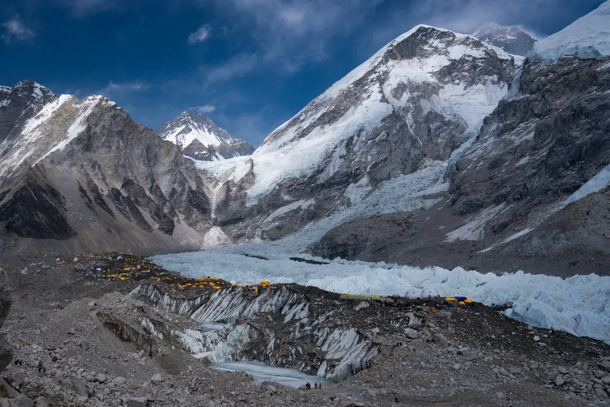
Everest Base Camp on the Khumbu Glacier. Photo: Nirojsedhai, CC BY-SA 4.0, via Wikimedia Commons
Quick answer Everest Base Camp at a glance
Everest Base Camp on the Nepal side sits at 5,364 m (17,598 ft) on the Khumbu Glacier, while the north base camp in Tibet is given as 5,200 m (16,900 ft). The south camp is where climbers on the southeast ridge route start and where about 40,000 trekkers a year arrive on foot from Lukla. Trekkers cannot camp at the camp itself, so most sleep at Gorak Shep at 5,164 m (16,942 ft), the last village with accommodation. The walk from Gorak Shep takes 1.5 to 2.5 hours each way.
Key takeaways
- The full trek there and back is a guided Everest Base Camp Trek 14 Days with Lukla flights and permits included at $1,800 per person, or the Everest Base Camp Trek Lodge to Lodge at $1,475 per person.
- Short of time, a shared Everest Base Camp Helicopter Landing flies from Kathmandu toward the camp and Kala Patthar and back in 5 to 6 hours for $1,600 per person, with landings only if the weather allows.
- The north side is a road trip: the Tibet Everest Base Camp Tour runs 8 days from Lhasa to the camp at 5,200 m for $969 per person with the Tibet permit included.
- Check what the temperature does through the year in the weather table, and how the altitude at 5,364 m affects your body before you book.
Two Base Camps: Nepal and Tibet
There is no single Everest Base Camp. The south camp in Nepal and the north camp in Tibet sit on opposite sides of the same mountain and are reached in completely different ways.
South and North Side by Side
The two camps are often confused, so the table below sets them side by side. Heights come from Wikipedia's Everest Base Camp article, with other figures named where a source differs. The biggest practical difference is access: on the Nepalese side climbers fly to Lukla and trek in, while on the Tibetan side most climbers drive directly to the north camp.
Note also that the north camp has a tourist zone with a tent village, while the south camp exists for expeditions and the trekking trail ends just short of it.
| Feature | South (Nepal) | North (Tibet) |
|---|---|---|
| Height | 5,364 m (17,598 ft) per Wikipedia. Alan Arnette and Tibet Travel give 5,334 m (17,500 ft) | 5,200 m (16,900 ft) in the Wikipedia infobox and body. Alan Arnette gives about 17,000 ft (5,182 m) |
| How you get there | Fly from Kathmandu to Lukla, then trek in. About 40,000 people a year make the trek from Lukla Airport | A 100 km road branches from the Friendship Highway near Shelkar. Private cars stop at the camp. Tourists finish by government-managed horse-drawn carriage or small bus |
| Where tourists stop | The trail ends at the camp itself, reached on foot from Gorak Shep | A marked tourist point below the camp, at a hill given as 5,200 m |
| Sleeping | Trekkers cannot camp there under their permits. Most sleep at Gorak Shep, 1.5 to 2.5 hours away | A tent village for tourists with a tea house and pit toilets sits in the tourist zone |
| Season | Spring March to May and autumn September to November. Expedition tents fill the glacier in spring | April to May and September to October per Tibet Travel. Tibet typically closes to foreigners around Tibetan New Year and reopens late March or early April |
The South Camp on the Khumbu Glacier
The south camp sits at coordinates 28 degrees 0 minutes 26 seconds N, 86 degrees 51 minutes 34 seconds E on the Khumbu Glacier, which runs about 17 km from 4,900 m at its terminus to 7,600 m at its source and ends in the Khumbu Icefall. Its facilities are a rudimentary field hospital and a heliport, with supplies carried in by porters and usually yaks. In spring the glacier becomes a small city: Sherpas arrive as early as February to mark camp sites, and Alan Arnette's dispatch from the main camp at the foot of the icefall described about 20 teams, each with its own sleeping tents plus support tents for eating. Camps must be rebuilt every year because the glacier moves under them.
The camp has also seen disaster. A 7.8 earthquake on 25 April 2015 triggered an avalanche from Pumori that swept through the camp and killed at least 19 people. An ice collapse in the Khumbu Icefall on 18 April 2014 killed 16 Nepalese Sherpa guides, and by 2017 Wikipedia counted 66 deaths in the icefall. In June 2022 it was announced that the camp would move 200 to 400 m lower because the glacier is melting.
The North Camp and the Tourist Point
The north camp in Tibet sits at coordinates 28 degrees 8 minutes 29 seconds N, 86 degrees 51 minutes 5 seconds E on gravel that Alan Arnette describes as windy. Expeditions set up near the Rongbuk Glacier about 8 km south of Rongbuk Monastery, which stands at about 4,980 m (16,340 ft) and was founded in 1902. The camp is the furthest point private cars can reach, and it is also where all vehicle-assisted evacuations start, since the road ends there.
Ordinary visitors stop at a tourist point below the camp, where Wikipedia describes a tent village, a tea house and pit toilets, with the climbers' tents in a restricted area beyond. Reaching it requires a permit from the Government of China on top of the Tibet Travel Permit. Access has not been stable: Abenteuer Berg reported in 2019 that China closed its camp to non-climbers, and Alan Arnette records that foreigners were barred from the Tibet side from 2020 through 2023. The sources conflict on whether tourists can reach the camp today, so confirm current access with your operator before booking anything.
Sources: Wikipedia, Mount Everest, Wikipedia, Sagarmatha National Park
How High Base Camp Is and What It Does to You
At 5,364 m the south camp sits far higher than Lhasa, and the numbers matter more than the views.
The Heights and the Conflicts
The most widely used figure for the Nepal camp is 5,364 m (17,598 ft), given by Wikipedia and by listings such as Nepal Hiking Team and Alpine Ascents. Alan Arnette and Tibet Travel give 5,334 m (17,500 ft). The 30 m gap is a surveying and marking question rather than a physical change, so treat both as the same camp. For the north camp, Wikipedia gives 5,200 m (16,900 ft) in both infobox and body, while one line in the same article's introduction says 5,150 m, Abenteuer Berg says 5,200 m and Arnette says about 5,182 m (17,000 ft).
For scale, Everest itself is 8,848.86 m (29,031.7 ft) from the 2020 joint Nepal-China survey, though Tibet Travel gives 8,844.43 m. Climbers usually start their ascent from base camps above 5,000 m (16,404 ft), and the south route then rises through camps at 5,943 m, 6,400 m and 7,162 m to the South Col at roughly 8,000 m on Arnette's figures, while Alpine Ascents puts that last camp at 8,016 m. Lhasa, by comparison, sits at 3,656 m and its air already holds roughly two-thirds the oxygen of sea level, so the camp is far thinner again.
Acclimatisation, Symptoms and Insurance
Altitude sickness typically occurs above 2,500 m and symptoms often show within ten hours of ascent, so the whole Everest Base Camp trek is in the risk zone. Wikipedia advises ascending no more than 300 m (1,000 ft) per day to sleep above 3,000 m, while operator Himalayan Hero allows 300 to 500 m and recommends a rest day for roughly every 1,000 m gained, using climb high, sleep low. Ian Taylor Trekking argues two standard acclimatisation days are not enough and builds three nights in Namche Bazaar at 3,440 m (11,290 ft) into its itineraries.
Know the symptoms: Himalayan Hero lists headache, nausea, fatigue, dizziness and poor sleep for acute mountain sickness. Drink 3 to 4 litres of water daily and never go higher with worsening symptoms, because HACE needs immediate descent. Wikipedia lists acetazolamide at 125 mg twice daily for prevention, started about 24 hours before ascent, which you should discuss with a doctor. The Himalayan Rescue Association aid post at Pheriche is staffed twice yearly in the trekking season by volunteer doctors, open roughly March to May and October to December. Finally, check that your insurance covers trekking to 5,364 m.
I Visited Mount Everest Base Camp
A traveller walks up to the south base camp on the Khumbu Glacier. Third-party video by Luke Korns. This site did not shoot it and has no relationship with the creator.
Base Camp Through the Year
Night temperatures at the camp drop far below freezing for most of the year, and the two main operator guides disagree by a few degrees in every month.
Temperature Month by Month
The table compares night lows at the Nepal camp at 5,364 m from Kandoo Adventures and Everest Trekking Routes, the two sources that publish monthly figures, alongside what is actually at the camp or on the trail in each period. Sources differ by 2 to 6 degrees in every month, so plan for the colder figure. There is no stated figure for June, July, August or September, which fall in or just after the monsoon.
Tibet Travel gives April to May and September to October as the best time to visit the north camp.
| Month | Night temperature | What is there |
|---|---|---|
| March | -17C (Kandoo) or -15C (Everest Trekking Routes) | Spring season starts. Sherpas reach the south camp from February to mark sites |
| April | -12C (Kandoo) or -10C (Everest Trekking Routes) | Peak spring. Expedition tents fill the glacier. Best time for the north camp per Tibet Travel |
| May | -8C (Kandoo) or -5C (Everest Trekking Routes) | Spring season ends. Monsoon rains usually arrive between late May and late June per Followalice |
| June to August | not stated | Monsoon, with most of Nepal's annual rain. Off-peak on the trail |
| September | not stated | Autumn season opens. Monsoon generally ends by mid or late September per Followalice |
| October | -9C (Kandoo) or -12C (Everest Trekking Routes) | Rooms fill fast and solo trekkers may end up on a dining hall bench |
| November | -12C (Kandoo) or -18C (Everest Trekking Routes) | Autumn season closes. High winds above the lower section peak from late November, gusting around 30 kmph |
| December to February | -25C (Everest Trekking Routes) | Off-season. Most Gorak Shep accommodation closes and January snow is possible near the camp |
The Two Seasons
The Everest region has a spring trekking season of March to May and an autumn season of September to November, per Kandoo Adventures. Spring brings the climbing expeditions, so the south camp is at its fullest and liveliest, with expedition tents covering the glacier. Autumn has stable weather and clear views, with October described by Himalayan Vista Trekking as one of the best months for drier trails.
The trade-offs are real. Rooms in October and November fill fast, so book lodges or a guided package early. From December to February most lodges at Gorak Shep close and high-pass routes shut, so the camp is effectively out of reach for ordinary trekkers. The monsoon from June to August brings most of Nepal's annual rain. For the north side, Tibet Travel's window of April to May and September to October matches the Nepalese seasons, with Tibet itself closing around Tibetan New Year and reopening late March or early April.
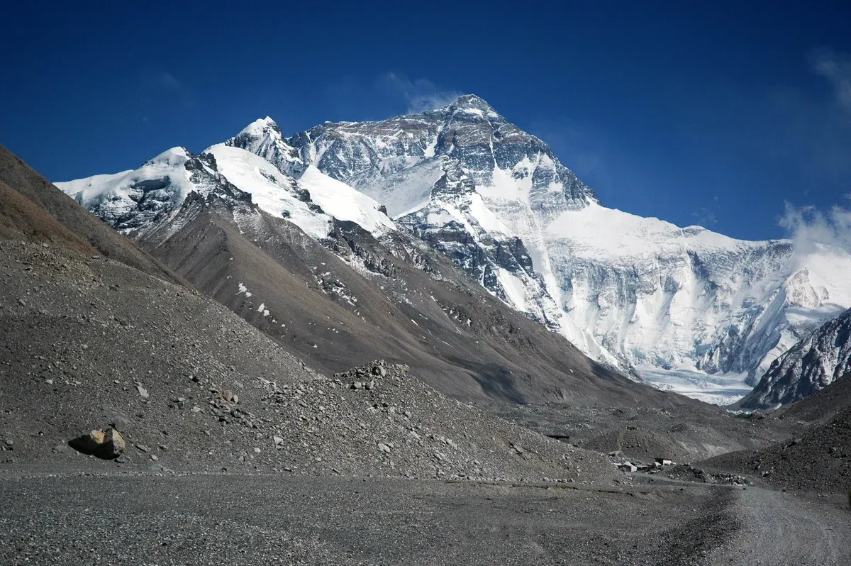
Everest from the Rongbuk valley near the Tibet base camp. Photo: Ocrambo, public domain, via Wikimedia Commons
Three Ways to Reach Base Camp
You can walk in, fly in by helicopter, or drive in from Tibet. Each has a different cost, time and fitness price.
The Trek
The classic route starts with a flight to Lukla at 2,846 m (9,337 ft) and climbs through Namche Bazaar at 3,440 m (11,290 ft), Dingboche and Lobuche at 4,940 m (16,210 ft) to Gorak Shep, the last village with accommodation at 5,164 m (16,942 ft). From there the camp is a 1.5 to 2.5 hour walk each way. Most guided trips run 12 to 14 days, which leaves room for the acclimatisation days that keep you safe.
Guided options on this site include the Everest Base Camp Trek 14 Days at $1,800 per person with 1,656 reviews, Lukla flights including airport departure tax and both regional permits included, and the Everest Base Camp Trek Lodge to Lodge at $1,475 per person with full board, a 2 to 15 group and a minimum of 2 people per booking. The cheaper Everest Base Camp 12 Days runs at $955 per person with return Lukla flights and permits included. The day-by-day stages, distances and lodge stops are covered in the Everest Base Camp trek guide, and permit costs are set out in the costs and fees section of the homepage.
The Helicopter
Helicopters can put you beside the camp in a single day from Kathmandu. The Everest Base Camp Helicopter Landing runs 5 to 6 hours for $1,600 per person, with five passengers sharing one helicopter and hotel pickup included. National park fees, municipal tax and airport tax are not included. The landing itself is always subject to weather, and Nepalese rules have tightened: after a crash in November 2023 that killed six people, the park authority restricted landings, allowing regular flights to land only at Lukla, Namche and Syangboche, with flyovers of Kala Patthar and the camp permitted under a rule of four landings that splits five passengers into groups of two or three under 250 kg.
A softer version is the Everest View Hotel Helicopter Breakfast at $1,352 per person for 6 hours, with a landing at Kala Patthar or the camp only if weather allows and breakfast at the hotel at 3,880 m. Trekkers can also fly out instead of walking down: Wikipedia says flights from Gorak Shep take about 25 minutes to Lukla and about 90 minutes to Kathmandu, and the EBC Trek with Helicopter Return at $2,250 per person builds a helicopter flight from Gorak Shep to Lukla into its 12 days. Note that no landing is ever guaranteed.
The Tibet Road
The north camp is the only one you can drive to. From Lhasa the route is about 700 km (430 miles), typically three days, running through Gyantse and Shigatse and down a 100 km road from the Friendship Highway near Shelkar. Foreigners cannot travel in Tibet independently: you need a Chinese visa, a Tibet Travel Permit issued through a registered agency, and an Aliens' Travel Permit for places outside Lhasa including the camp. Coming from Nepal instead, you need a China Group Visa from the embassy in Kathmandu and usually 3 to 6 days in Nepal for the permit process.
The straightforward way to handle the paperwork is an organized trip like the Tibet Everest Base Camp Tour, an 8-day journey from Lhasa at $969 per person with the Tibet Travel Permit and site entrance tickets included, though the flight or train to Lhasa and the Chinese visa are not. Book at least 10 working days ahead for the permit and send passport copies 20 days before travel. Remember the access question: sources conflict on whether non-climbers can currently reach the north camp, so confirm before paying.
Do and Don't at Everest Base Camp
Do
- Do plan at least 12 days for the trek because Wikipedia advises no more than 300 m of sleeping-altitude gain per day above 3,000 m, and Ian Taylor Trekking says two acclimatisation days are not enough.
- Do book October and November accommodation far ahead because rooms fill fast and solo trekkers may end up sleeping on a bench in the dining hall.
- Do carry 3 to 4 litres of water daily because Himalayan Hero names hydration as core acclimatisation advice and says never to ascend with worsening symptoms.
- Do learn the AMS symptoms of headache, nausea, fatigue, dizziness and poor sleep because HACE needs immediate descent and the aid post at Pheriche is only staffed during the trekking season.
- Do buy insurance that covers 5,364 m because the south camp sits at 5,364 m and your policy needs to cover that height.
Don't
- Don't plan to sleep at the camp itself because Wikipedia says trekkers cannot camp there under their permits, so Gorak Shep is the practical overnight stop.
- Don't treat a helicopter landing as certain because landings at Kala Patthar and the camp are subject to weather, local permission and post-2023 restrictions that allow regular flights to land only at Lukla, Namche and Syangboche.
- Don't go in the monsoon or deep winter because June to August brings most of Nepal's annual rain, December to February nights reach -25C and most Gorak Shep lodges close.
- Don't assume the north camp is simply open because sources conflict on tourist access since 2019 and Tibet closes to foreigners around Tibetan New Year, so confirm current status with a licensed agency.
Everest Base Camp Questions
How high is Everest Base Camp?
The south camp in Nepal is given as 5,364 m (17,598 ft) by Wikipedia, with Alan Arnette and Tibet Travel giving 5,334 m (17,500 ft). The north camp in Tibet is given as 5,200 m (16,900 ft), though other sources say 5,150 m or about 5,182 m. See the altitude section above for what these heights do to your body.
Where is Everest Base Camp?
The south camp sits at 28 degrees 0 minutes 26 seconds N, 86 degrees 51 minutes 34 seconds E on the Khumbu Glacier in Nepal, on the southeast ridge route. The north camp sits at 28 degrees 8 minutes 29 seconds N, 86 degrees 51 minutes 5 seconds E in Tibet near Rongbuk Monastery. The trek in from Nepal is covered in the Everest Base Camp trek guide.
Can trekkers sleep at Everest Base Camp?
No. Wikipedia says trekkers cannot camp at the camp under their permits, so most stay in Gorak Shep at 5,164 m, the last village with accommodation, and walk 1.5 to 2.5 hours to the camp.
How hard is the walk to Everest Base Camp?
The final walk from Gorak Shep to the camp takes 1.5 to 2.5 hours each way depending on weather, acclimatisation and fitness, at an altitude above 5,000 m. The difficulty comes from the height rather than the terrain, which is why acclimatisation days matter. The full route is described in the Everest Base Camp trek guide.
What is the temperature at Everest Base Camp?
Night lows at the Nepal camp range from -5C to -8C in May up to -25C from December to February, with Kandoo Adventures and Everest Trekking Routes giving figures a few degrees apart in every month. See the month-by-month table above for both sources.
Can you drive to Everest Base Camp?
Only to the north camp in Tibet, at the end of a 100 km road from the Friendship Highway near Shelkar, about 700 km from Lhasa. Foreigners need a Tibet Travel Permit, an Aliens' Travel Permit and an organized tour, which the Tibet Everest Base Camp tour page handles. The Nepal camp is reachable only on foot or by helicopter.